![]()
GIS stands for GeographicInformation System. A GIS is “an organized collection of computer hardware,software, geographic data, and personnel designed to effectively capture, store,update, manipulate, analyze, and display all forms of geographically referencedinformation.”
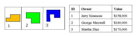
While a conventional database limits one to questions like “Which properties are valued at greater than $90,000?,” a GIS can be used to answer questions such as “Which properties are adjacent to my property?” The GIS user can ask questions of, or query, the database in ways that are not possible with conventional databases. The ability to perform dynamic queries permits the evaluation of current conditions and enables the modeling of future scenarios.
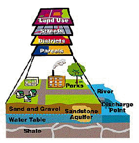
One of the most powerful features of geographic analysis is the ability to compare different layers of information. Just as a County agency may store information in different databases, a GIS stores information in thematic layers. Suffolk county data can be divided into layers such as streets, hydrology, buildings, etc. Each layer is managed separately in a GIS. This concept is illustrated in the graphic above.
A GIS can provide a unique insight into many difficult problems. Suffolk county has successfully used GIS since 1986 to develop solutions to a host of problems encountered by County agencies and departments. These problems range from mapping the locations of County owned facilities to creating new County Geographic information to analyzing the spatial distribution of properties. The benefit of a GIS is that it provides a graphical representation and an intelligent database about the inventory of geographic elements. This inherent ability of GIS to locate features spatially adds a great-deal of power and flexibility to a database.
A GIS can be applied to many types of problems. For any-application thereare six generic questions that a sophisticated GIS can answer.
LOCATION - What is at..?
The location question involves
|
|
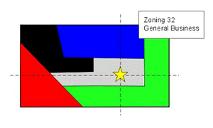
CONDITION - Where is at..?
The condition question involves finding the location of sites which have veryspecific characteristics (e.g. where are all parcels with an accessed valuebetween $200,000 and $225,000).
|
|
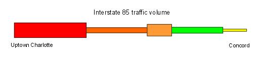
TREND - What has changed..?
The trend question involves monitoring how conditions change over a period oftime (e.g. what is the change in traffic flow along interstate 85 between 6:00a.m. - 9:00 a.m., 9:00 a.m. - 3:00 p.m., 3:00 p.m. - 7:00 p.m., and 7:00 p.m. -6:00 a.m.?)
|
|
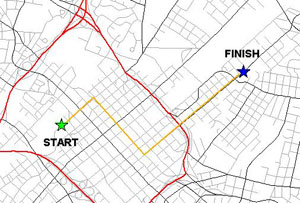
ROUTING - What is the best way..?
The routing question requires the calculation of the best (easiest, quickest,shortest, etc.) route between locations.
|
|
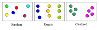
PATTERN - What spatial pattern exists..?
The pattern question allows planners to describe and compare the distribution ifthings and to understand the processes which account for their distribution(e.g. is there a certain pattern in the increase of cancer which is thought to be caused by groundwater contamination?)
|
|
MODELING - What if..?
"What if..." questions are posed to determine what happens, forexample, if a new road is added to a network, or if a toxic substance seeps intothe local groundwater supply.
|
|
A GIS is an invaluable tool for data visualization and analysis. Overeighty percent of decision made by local government are constrained, influenced,or dictated by some fact of geography. All of the above questions areanswered more quickly and efficiently with a GIS.
This page was last modified Nov 21, 2004